
 Wallace Street slide in 2012
photo CC SA-BY Our Oakland
Beware Oaklanders! The land beneath your feet may not be as stable as it seems. Below is a listing of Oakland's urban landslides over the years. (H/T to Oakland Geology blog.)
| Year | Location | Description | |
| 1910s | Between Ransom Avenue and Santa Rita Street | Landslides in 1911 and 1914 took out houses on four adjoining lots. More sliding reportedly occurred in the 1930s. In 1977 the Santa Rita Land Trust was organized to acquire the ruined lots, which became the city open space known as Jungle Hill.11 | |
| 1926–1927 | Lerida Avenue |
A "dozen homes were heavily damaged" and 7 families vacated their homes in a slide in 1926; possibly further damage in 1927. The movement of the earth broke the sewer line between the houses between the 700 block of Lerida and Calmar Avenue. A unknown number of homes were lost. Neighborhood rumor says one house slid down into the street, and was subsequently rotated 180' and relocated to the opposite side of the street.
Lerida Avenue was renamed Balfour because of the notoriety. The 1936 map shows the part below Rosal Avenue named Balfour and the rest still named Lerida; by the 1950 map it is all named Balfour. See City Will Bore to Find Cause of Lerida Slide Oakland Tribune, February 22, 1926. In 1927 the city spent $17,000 to install a drainage system where the broken sewer line had been.
As current evidence of the earth's movement, there's extensive displacement on the pedestrian stairway that runs uphill from Balfour to Calmar. For some ninety years, the lots where homes had been lost remained vacant - but the boom in prices and demand for new housing is now resulting in new construction. |
|
| 1935 | McKillop Road | A "massive landslide" 1 occurs as a large chunk of the west bank of Sausal Creek washes away and McKillop Road is cut in two. W.D. Wood Park is founded on the remains of the slide. | |
| 1938 | Park Blvd. | A series of storms caused 20 deaths and damage across the state, including the collapse of a 100' section of Park Blvd. |
 |
| 1956 | Doncaster Place | Mudslide that started on Merriewood Drive and crossed 3737 Valley View Drive swept a house down the hill and blocked Thornhill. Widespread flooding, small slides and road blockages in Oakland after nearly 4 inches of rain fell over three days. 10 |
 courtesy Chris Treadway courtesy Chris Treadway |
| 1958 | Lincoln Square | See The Lincoln Square landslide of 1958 on OaklandGeology.com | |
| 1962 | widespread | Series of storms led to flooding and landslides all over Oakland. One fatality on Kimberlin Heights Drive, damage all around Oakland 7 | |
| c.1966 | Chelton Drive | 6177 and 6163 Chelton Drive "are as good as gone". One house may have been designed by Beverley Thorne. (ref) | |
| 1970 | Area between Jordan Road, London Road, and Kitchener Court. | A large slide takes out a section of London Road and 14 homes just below the Mormon Temple. The area is still uninhabitable. 2 | |
| 1982-1983 | Armour Drive + Snake Road | A major slide destroyed four homes, and Armour Drive was closed. | |
| 1998 | Rettig Avenue | El Niño storms cause a landslide that blocks the street and covers the bank of Peralta Creek.3 That winter, Oakland received 229 percent of its annual average rainfall by 1 April, and numerous smaller slides occurred all over the city, e.g. on 19th Avenue at E. 27th Street. 12 |
 CC SA-BY Our Oakland CC SA-BY Our Oakland |
| 1998 | Armour Drive + Snake Road | Two homes, 6757 Snake Road and 6801 Snake Road were destroyed in a slide. 8,9 | |
| 1998 | Redwood Road and Geranium Place | Part of Redwood Road slid, pushing houses on Geranium Place off their foundations. Ultimately 3 houses were demolished. | |
| 2002 | Wallace Street | A prolonged wet spell causes a month-long, slow motion mudslide that results in the red-tagging of several homes overlooking 14th Avenue.4 |
CC SA-BY Our Oakland |
| 2006 | McKillop Road | After a lapse of several decades, the unstable ground near McKillop starts to move again, resulting in the destruction of several more homes.5 | |
| ? | San Luis Avenue and Dolores Avenue | Does anyone know about this one? There appears to be a slump and several vacant lots. | |
| 2005–2006 | Armour Drive + Snake Road | A large slide below Snake Road permanently closed part of Armour Drive and destroyed at least one house. New houses have been built on the lots that the landslides left empty. |
 CC SA-BY Our Oakland CC SA-BY Our Oakland |
| 2012-1-21 | Wild Currant Way | Wet weather may have caused a water main break. Wet weather collapses road in Oakland Hills on KTVU | |
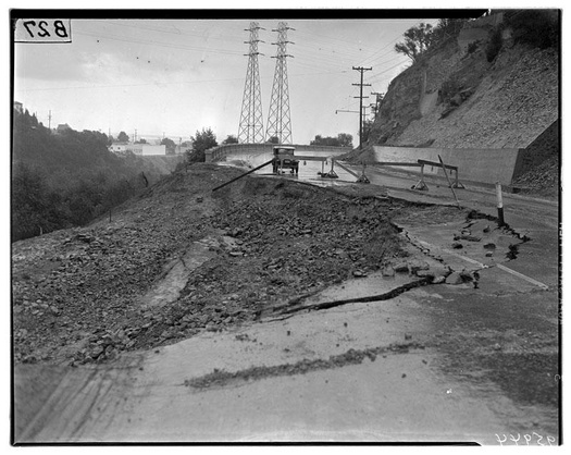
| 2012-5-5 | Near Sheridan and CA-13 | Caltrans is spending approximately $7 million to repair damaged caused by a slide along the former Sacramento Northern right of way.6 |
 CC SA-BY Our Oakland CC SA-BY Our Oakland |
| 2017-04/05 | Montclair Railroad Trail | Two separate slides blocked the trail: one at the Melin Cut, and another close to Bishop Ct. |
 CC SA-BY Our Oakland CC SA-BY Our Oakland |
 new construction at Armour Dr. in 2014 CC SA-BY Our Oakland
Charles H. Lee was a hydraulic engineer who worked for the USGS, the city of Los Angeles, and others, as well as having private practice. Lee wrote about numerous aspects of water history in California. He wrote a booklet about the Lerida Avenue slide, and another about the McKillop Road slide.
Links and References
- Background on Geologic Hazards in the City of Oakland oaklandnet.com
- The Sausal Creek Watershed, A Cultural and Natural History
- The Kitchener Scarp on Oakland Geology
- http://www.macarthurmetro.org/200406/dimond/444 (dead link, not on archive.org)
- Storm threatens homes in Oakland SFGate.com March 8, 2002
- The McKillop landslide: Ten years after on Oakland Geology
- California Transportation Commission vote summary for October 24, 2012 (see bottom of page 5)
- City Faces $400,000 Flood Suits Oakland Tribune January 31, 1963
- Sliding Oakland Hills Home on Verge of Demolition San Francisco Chronicle January 28, 1998
- California’s next worry: mudslides from El Niño rains San Francisco Chronicle October 23, 2015 (note video footage of Snake Road)
- Rains Deal Havoc in North Calif. Oakland Tribune January 16, 1956, p. 1 and 7
- What Happened to Jungle Hill?. MacArthur Metro, August 2007 (via archive.org)
- Miscellaneous Field Studies Map 2325. (El Nino landslide map of the S. F. Bay area; US Geological Survey, 1999--pamphlet contains photo of the 19th Avenue house)

