
 1961 BART map showing lines proposed for the five-county plan. [source]A number of ambitious public-works redevelopment projects (and some private ventures) in Oakland have been proposed, but never built. This page is here to collect the most interesting ones:
- The Viaquadrome, or Bridge of Great Beauty, was a bridge proposed in 1938 that would have spanned Lake Merritt and carried a four-lane freeway. More in this Oakland Standard article from May 24, 2012.
- The Reber Plan was an outrageously ambitious plan in the 1940s that would have dammed most of the San Francisco Bay, and included a 24-lane land bridge to San Francisco, among other projects.
- Highway 77 was a freeway planned through Shepherd Canyon, connecting to Highway 13 and Park Blvd. See assembly member Ken Meade, 1972 - AB561, and sign on Montclair RR Trail. Maps of the western portion and eastern portion of the proposed freeway within Oakland are available in Erica Fischer’s Flickr feed.
- The Richmond Blvd. Freeway would have started at 19th Street adjacent to Snow Park, then followed Glen Echo Creek along Richmond Blvd., behind Piedmont Ave., to Moraga Ave., and thence to Highway 13. It was approved in the 1940s (and not killed until 1956, when Piedmont refused to fund their portion). Maps of the downtown segment and northeastern portion of the proposed freeway are available in Erica Fischer’s Flickr feed.
-
BART, as originally conceived, included many more stops than ended up being built (see the map at right).
- Lots of interesting reading on BART history on Wikipedia.
- Interesting Master’s thesis and slide show that includes plans for BART and other similar systems: No Little Plans: Exploring Rapid Transit Development Through the Lens of Plan Design
- Check out this imaginary BART map created in 2011. It will make you cry.
- Collis Huntington (of The Big Four) wanted to fill in the lake and build a large railroad station. Leland Stanford (also of The Big Four) convinced him instead to donate the land. The family of Leland’s brother Josiah Stanford lived at Camron-Stanford House on Lake Merritt.
- According to Oakland’s Neighborhoods by Erika Mailman, big game hunter Henry Snow (see the Snow Museum) wanted the city to dig a 40-foot cave (!) on the Lakeshore edge of Lake Merritt, which he would supply with lions, rhinos, hippos and giraffes. The kicker was that the animals would not be caged, only contained by a moat too deep and wide for them to escape.
-
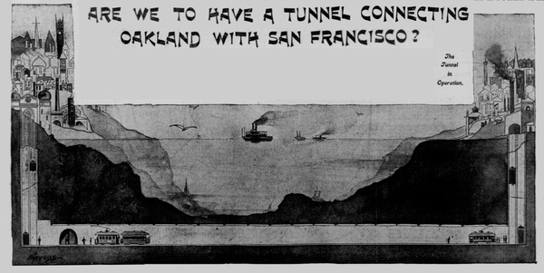
1890s: Imagine…BART. There were two different tunnel proposals. One, c.1888 from Dr. Edward Parsons of San Francisco, would have run from about Hunter’s Point to western Alameda. The plan was worked on by engineer Julian Le Conte and considered viable. Dr. Parsons had the backing of English investors, but that fell through when an English Channel tunnel was refused by the English government. A later version of the idea would use electric trains. In 1900, the tunnel idea was revived, and presented to Congress by Congressman Kahn. It would have run from the foot of Market Street in SF to Goat Island (aka Yerba Buena Island) to Oakland. Read the article in the S.F. Call: (Vol. 87 #80, 1900-02-18, p.6).
-
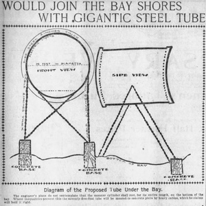
1901: Another tunnel idea...a 75' diameter steel tube running along the bottom of the shallows, and suspended in deeper water. An idea from engineer F. I. Matthews of Bay City Iron Works. See "Would Join the Bay Shores With Gigantic Steel Tube" in the April 28, 1901 San Francisco Examiner.
-
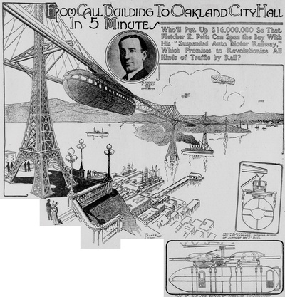
1910: Tomorrowland meets BART. Or was it the Hyperloop of the early 1900s? Imagine an elevated monorail system speeding across the bay. That’s what Fletcher E. Felts did with his “Suspended Auto Motor Railway”. See "From Call Building to Oakland City Hall in 5 Minutes" in the April 17, 1910 San Francisco Call.
-
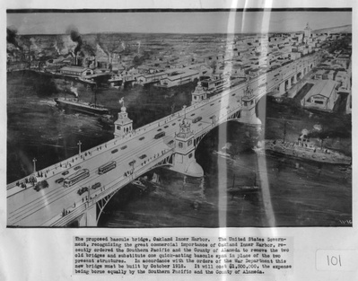
1917: A bridge that never was. This was proposed for “Oakland’s Inner Harbor” to replace the existing bridges. This likely refers to the ill-fated Webster Street Bridge.
 c.1917, from Oakland History Room
 -
1921: The Union Construction Company proposed a floating bridge (p2) to cross the Bay. Various routes were possible, including a more southerly route shown in the diagram.
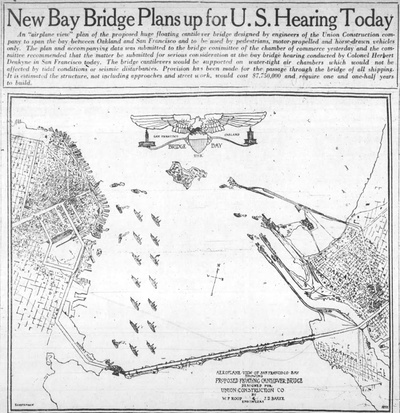 1921 Oakland Tribune
 -
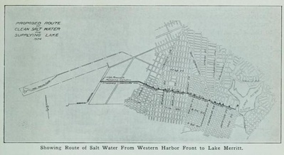
1924: Mayor John Davie wanted to build a saltwater pipeline from West Oakland to Lake Merritt along 14th Street. The water would be delivered into the lake by “cascade fountains located at certain points around the lake,” The outflow of Lake Merritt would be reduced to a single concrete pipe. All of this would allow completely filling the channel from the lake, in order to utilize the land. Read more in the Mayor’s Message in the 1924 Polk’s directory.


.jpg/_info/)

-
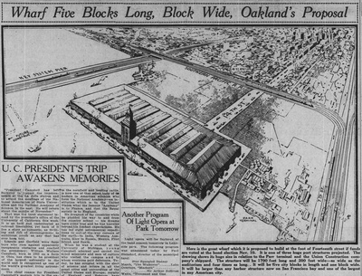
1925: Plans for a massive wharf building at the end of 14th Street were proposed. The building would been 1700 feet long and 200 feet wide.
-
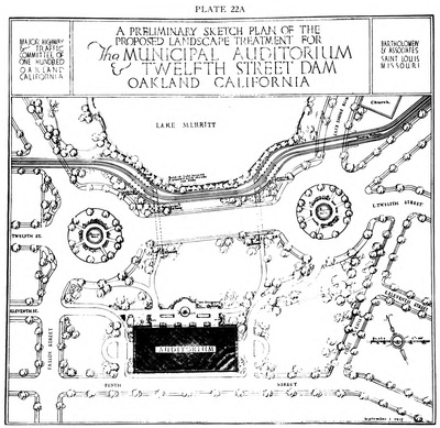
1927: A proposed plan for a system of major traffic highways, Oakland, California was created for the Committee of One Hundred, looking to improve and increase traffic flow through the city. Some of it was widening and extending existing streets (much of which happened eventually), but also included plans for cutting new streets through existing blocks, a 12-lane (+ 2 train lines) "super highway" near the shoreline, and an interesting plan for the 12th Street Dam using roundabouts. As the channel between Lake Merritt and the estuary doesn't appear in the plans, presumably the water would be culverted.
- 1957: An 'international fleet' for Lake Merritt. Jack Francis, the concessionaire who operated the Oakland Acorn at Peralta Playland, envisioned a small fleet of international vessels near Children's Fairyland. Models were shown, including a Chinese junk, a Venetian gondola, and a Viking ship. Also proposed was a miniature Portuguese village, a goodwill gift from Portugal.
-
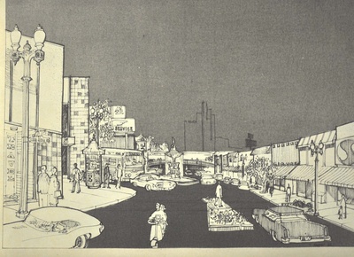
c.1960: Check out this improvement plan for Lakeshore Avenue. There would have been a fountain similar to the one in Berkeley at the Marin Avenue circle, and a pedestrian overcrossing where the crosswalk between Peet’s and Chipotle is now. Thanks to Ken Katz and Lakeshore Homes Association for the drawing from the plans. National Park Service landscape architect William Penn Mott, Jr. was part of the group that drafted the recommendations.
-
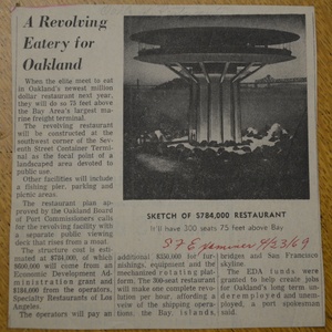
1969: An elevated, revolving restaurant near the port? Whose Googie-ness would put Biff’s to shame? It was approved by the Port Commission, but never built. And how can you dislike any article that starts with “When the elite meet to eat…”?
-
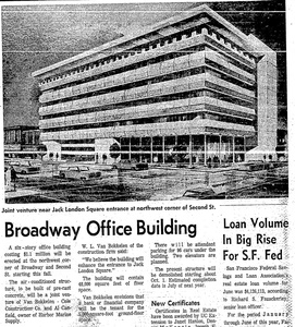
1967: A mod-looking office building for the northwest corner of Broadway and 2nd Street.
-
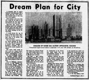
1965: A 55-story building as part of City Center redevelopment.


See also
- Oakland Master Plan
- Unbuilt LA Exhibit
- Exhibition imagines a different S.F. Skyline San Francisco Chronicle August 14, 2013
- Seems like “unbuilt” is having something of a moment. This 99% Invisible podcast is all about the “unbuilt” and includes the 1910 “suspended auto railway” plan: http://99percentinvisible.org/episode/unbuilt/
… Now that we’ve learned about Unbuilt Oakland, what about Future Oakland?

